We are just getting your request from the archives. Please note some videos may take a minute or so to load.
-
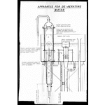
207121PD: Diagram relating to the Goldfields Water Supply scheme. Apparatus for de-aerating water, between 1903 and 1927.
-
207126PD: Graph relating to the Goldfields Water Supply scheme, between 1903 and 1927.
-
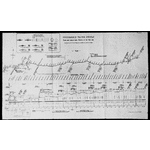
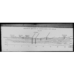
207133PD: Diagram relating to the Goldfields Water Supply scheme. Coolgardie Water Supply : plan and longitudinal profile of the pipeline, between 1903 and 1927.
-
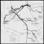
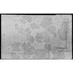
207148PD: Map relating to the Goldfields Water Supply scheme, between 1903 and 1927.
-
207149PD: Diagram relating to the Goldfields Water Supply scheme. Arrangement of inner valve-tower, between 1903 and 1927.
-
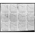
207150PD: Graph relating to the Goldfields Water Supply scheme. Friction - tests on 30 inch main : flow per hour with head of 1 foot, between 1903 and 1927.
-
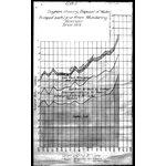
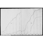
207155PD: Graph relating to the Goldfields Water Supply scheme. G.W.S. diagram showing disposal of water pumped each year from Mundaring Reservoir since 1918, 1927.
-
207156PD: Diagram relating to the Goldfields Water Supply scheme. Geological section of London Basin, with wells, between 1903 and 1927.
-

207157PD: Graph relating to the Goldfields Water Supply scheme. Mass curves of rainfall - Perth and Adelaide, 1927.
-
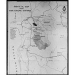
207158PD: Map relating to the Goldfields Water Supply scheme. Isohyetal map showing rain gauging stations, between 1903 and 1927.
-
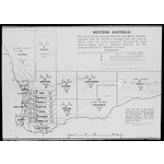
207159PD: Map relating to the Goldfields Water Supply scheme. Western Australia : map showing the average summer and winter rainfall, 1927.
-
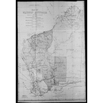
207160PD: Map of Western Australia, between 1903 and 1927.
Item Detail
Summary
Apparatus for de-aerating water -- Coolgardie Water Supply : plan and longitudinal profile of the pipeline -- Arrangement of inner valve-tower -- Friction - tests on 30 inch main : flow per hour with head of 1 foot -- G.W.S. diagram showing disposal of water pumped each year from Mundaring Reservoir since 1918 -- Geological section of London Basin, with wells -- Mass curves of rainfall - Perth and Adelaide -- Isohyetal map showing rain gauging stations -- Western Australia : map showing the average summer and winter rainfall -- Map of Western Australia.
Year
between 1903 and 1927.
Warnings and disclaimer
Title supplied by cataloguer.
Subjects
- Online image.
- Charts, diagrams, etc -- Water-supply -- Western Australia -- Photographs.
- Graphs -- Water-supply -- Western Australia -- Photographs
- View more on SLWA catalogue
Terms of use
For personal use only. To publish or display, contact the State Library of Western Australia.
Call Number
BA1374/1, 6, 13, 28-30, 35-40
Links & Sharing
Order a Copy
Copies of items can be ordered from the State Library collections for personal use, research, or public display and publication. Copyright and other restrictions may apply. For more information about this service please visit the State Library website.
Contribute
Can you provide any additional information about this item, or do you have any general feedback about the new State Library online media viewer? Please let us know using the form below.
Info & Help
You are using the State Library of Western Australia online media viewer. Use this app to view digitised items within the State Library catalogue.
Desktop keyboard shortcuts
| Key | Behaviour |
|---|---|
| i | show detail about this item |
| l | show linking and sharing options |
| o | show information about ordering a copy of this item |
| c | show contribution form |
| h | show help panel (this panel) |
| x | close side panel |