We are just getting your request from the archives. Please note some videos may take a minute or so to load.
Item Detail
Summary
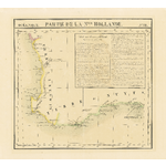
Rare.Chart of the coast of Terre de Leeuwin and Terre de Nuyts (from north of Jurien Bay to Cape Le Grand) showing main coastal features and visible inland ranges. From the portulan Océanique, no 52. Notes on new Holland continued from map no. 29 and continued on map no. 53. Battye accession no. 007941.
Year
1827]
Warnings and disclaimer
Originally published as map no. 52 in v. 6 (Oceanique) of: Atlas universal de geographie physique, politique, statistique et mineralogique. Relief shown pictorially. Portulan showing the coastline of W.A. from north of Jurien Bay to Cape Le Grand showing main coastal features and visible inland ranges. Notes on new Holland continued from map no. 29 and continued on map 53. Reference: Tooley no. 1290 (p. 160).
Subjects
Links & Sharing
Order a Copy
Copies of items can be ordered from the State Library collections for personal use, research, or public display and publication. Copyright and other restrictions may apply. For more information about this service please visit the State Library website.
Contribute
Can you provide any additional information about this item, or do you have any general feedback about the new State Library online media viewer? Please let us know using the form below.
Info & Help
You are using the State Library of Western Australia online media viewer. Use this app to view digitised items within the State Library catalogue.
Desktop keyboard shortcuts
| Key | Behaviour |
|---|---|
| i | show detail about this item |
| l | show linking and sharing options |
| o | show information about ordering a copy of this item |
| c | show contribution form |
| h | show help panel (this panel) |
| x | close side panel |